

Speedo MapTrack - GPS Speedometer with Maps

คำอธิบายของSpeedo MapTrack - GPS Speedometer with Maps
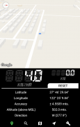
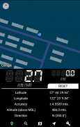
Speedometer and Maps stitched together!
Speedo MapTrack is ideal for people who want their location details (speed, distance etc.) along with their position & direction on Google Maps.
Can be used while travelling in train, bus, car etc.
Features:
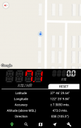
Split view of map and the speedometer console.
--- Map ---
• Supported up to 6 different themes.
• All the gestures & moves from google maps works.
• Map pointer moves along with the user's location.
• Shows live traffic on roads.
• Location search feature included.
• Also has a satellite view.
• Various power modes (affects accuracy).
--- Speedometer ---
• Speed - (km/hr, mi/hr, mtr/sec)
• Distance Travelled - (km, miles, meters)
• Latitude - (Decimals, DMS)
• Longitude - (Decimals, DMS)
• Altitude.
• Direction of travel.
• Accuracy of the location obtained.
• Speed limit alert/warning.
• Display precision can be set (decimal points).
• Supports 2 themes (Dark & Light).
วัดความเร็วและแผนที่เย็บเข้าด้วยกัน!
โด้ MapTrack เหมาะสำหรับผู้ที่ต้องการรายละเอียดตำแหน่งของพวกเขา (ความเร็ว, ระยะทางและอื่น ๆ ) พร้อมกับตำแหน่งและทิศทางของพวกเขาบน Google Maps
สามารถนำมาใช้ในขณะที่เดินทางในรถไฟรถบัสและรถอื่น ๆ
คุณสมบัติ:
มุมมองแบบแยกส่วนของแผนที่และคอนโซลหน้าปัด
--- --- แผนที่
•รองรับได้ถึง 6 รูปแบบที่แตกต่างกัน
•ท่าทางทั้งหมดและย้ายจาก Google Maps งาน
•ตัวชี้แผนที่จะย้ายไปพร้อมกับสถานที่ตั้งของผู้ใช้
•แสดงสดการจราจรบนถนน
•คุณลักษณะการค้นหาสถานที่ตั้งรวม
•นอกจากนี้ยังมีมุมมองดาวเทียม
•โหมดพลังงานต่างๆ (มีผลต่อความถูกต้อง)
--- Speedometer ---
• Speed - (กม. / ชมไมล์ / ชม mtr / วินาที)
•ระยะห่างเดินทาง - (กมไมล์เมตร)
•ละติจูด - (ทศนิยม, DMS)
•ลองจิจูด - (ทศนิยม, DMS)
•ระดับความสูง
•ทิศทางของการเดินทาง
•ความถูกต้องของสถานที่ตั้งที่ได้รับ
• จำกัด ความเร็วการแจ้งเตือน / คำเตือน
•จอแสดงผลที่มีความแม่นยำสามารถตั้งค่า (จุดทศนิยม)
•รองรับ 2 ธีม (มืดและแสง)


